Five years ago, drones on farms were mostly seen and demonstrated at agricultural shows. This new technology was impressive, but for many farmers not necessarily practical. Today, the same technology is used to detect crop stress at an early stage, apply pesticides with precision, and map damage after hailstorms within hours in order to plan solutions.
During a time when farmers are struggling with rising input costs, labour shortages and increasing climate uncertainty, drones have rapidly evolved from a technological novelty that sparked curiosity among producers into an established management tool on South African farms.
What do drones mean for agriculture?
In an agricultural context, drones refer to unmanned aerial vehicles (UAVs) equipped with cameras, sensors or spraying systems to collect data or apply inputs. Models range from lightweight reconnaissance drones fitted with multispectral cameras to larger spraying drones capable of distributing liquid or granular products across fields.
Where tractors and harvesters perform physical work, drones are used to obtain information – and in modern farming, information is often just as valuable as mechanical power.

Drones have now become essential farm tools for sustained, successful agricultural operations. (Source: Drone EFT)
From experimental to integrated tools
2020: Early adoption
In 2020, the use of drones on South African farms was still limited. The technology was expensive, local expertise was scarce, and regulations created uncertainty. Most applications focused on mapping and crop monitoring, primarily on larger commercial farms.
2021–2022: Acceleration
Following several success stories, the use of drones increased, and larger spraying drones entered the market. Interest in this type of technology grew rapidly. Service providers began offering drone services on a contract basis, reducing capital barriers for many farmers.
2023 to today: A management tool
Over the past few years, drones have begun to take their place in daily farm management. Medium-sized farms and progressive smaller producers now use them for crop health monitoring, precision application, irrigation management and even livestock tracking. Advanced functions – including NDVI imaging, biomass estimation, and thermal analysis – enable data-driven decision-making on a scale that was previously impractical.
Practical applications at farm level
- Crop monitoring and early detection
Multispectral and thermal cameras allow farmers to identify stress, disease and nutrient deficiencies at an early stage. Problem areas can be detected before they are visible to the naked eye, enabling timely intervention.

An aerial map showing crop health through colour gradients, which helps identifying early signs of rust disease. (Source: Dronelife)
- Precision application
Data from aerial imagery is used to compile variability maps, meaning that fertiliser, seed or chemicals need only be applied in specific areas. This targeted approach helps to limit input costs and use resources more efficiently.

A drone’s flight patterns are clearly laid out to show field coverage and routes. (Bron: Drones made easy)
- Spraying in difficult terrain
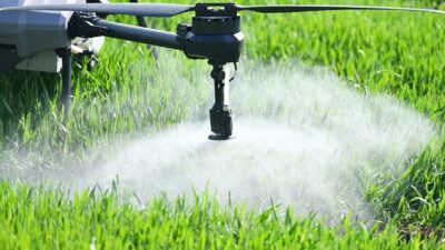
In vineyards, uneven fields or wet conditions where tractors cannot easily operate, spraying drones provide an alternative that reduces soil compaction and improves control over application.

An XAG drone is being used to spray in difficult terrain. This thermal image shows moisture stress and areas of over-irrigation. (Source: Perplexity)
- Water and irrigation management
Thermal imaging helps identify moisture stress and over-irrigation – a critical advantage in water-scarce regions such as parts of the Karoo and the Northern Cape.
 Source: Stockphoto |
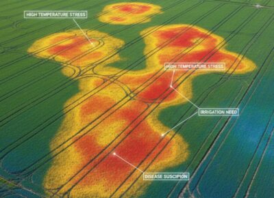 This thermal image shows moisture stress and areas of over-irrigation. |
- Livestock and infrastructure
On large grazing farms, drones are used to count livestock, inspect water points and fences, and locate animals in remote areas. This saves time and fuel costs while improving response time.
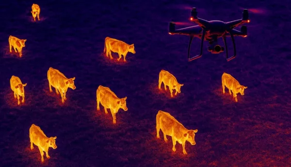
Sick animals can be detected by analysing temperature differences on heat maps. (Source: Stockphoto)
- Disaster assessment
After hailstorms or floods, damage can be mapped quickly, enabling faster insurance claims and more efficient recovery planning.
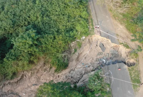
The South African Defence Force utilises drones to assess the extensive damage to infrastructure. (Source: Lieutenant Bafana Shepherd Mtshaise)
Farmers perspectives
Many farmers’ first reaction to drones was fairly sceptical. “I initially thought it was a toy,” says a maize and soybean farmer in the eastern Free State. “But when we started seeing how quickly we could identify problem patches after rain, it became a management tool.”
According to him, the greatest value lies in decision-making. “In the past, we treated entire blocks (fields). Now we treat patches. It sounds small, but over a season it makes a big difference to input costs.”
However, he points out that this technology is not a quick fix. “It isn’t cheap, and you must be able to interpret the data. A drone doesn’t replace management – it improves it.”
Regulations and practical considerations
The commercial use of drones in South Africa is regulated and requires appropriate licensing and training. For many producers, it is more practical to use licensed service providers rather than becoming operators themselves.
Although costs can still be a barrier for smaller farming operations, the growth of contract services has made access to this technology considerably easier.
Trends in Africa
Across Africa, drones are increasingly being used in both commercial and development contexts. In countries with large, dispersed production areas or limited infrastructure, drones offer a practical way to monitor crops and apply inputs more efficiently.
Climate variability and pest outbreaks are also accelerating the adoption of technologies that enable early warning and rapid responses.
Over the past five years, the use of drones has demonstrated that these tools are not merely an addition to mechanisation, but an extension of farm management itself. As equipment becomes more affordable and data analysis improves, the role of drones is likely to expand further – especially where precision, resource management and risk reduction are critically important.
Where drones were once regarded as a futuristic tool in agriculture, they are now becoming an indispensable instrument on farms that want to remain competitive and sustainable in the future.